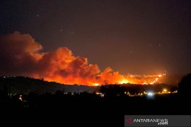
Medan (Antara Bali) - The NOAA Satellite detected 458 hotspots of forest and plantation fires across Sumatra on Tuesday afternoon, an official stated.
Most of the hotspots were located in northern Sumatra with a total of 430 hotspots, Hendra Suwarta, the head of the Medan meteorological, climatology and geophysics agency (BMKG)'s data and information service, stated here on Wednesday.
Northern Sumatra's 430 hotspots included 75 in Aceh Darussalam, 40 in West Sumatra, 242 in Riau and 73 in North Sumatra Province.
The 73 hotspots in North Sumatra were located across 17 districts and cities.
They included five hotspots in Langkat, five in Karo, five in Simalungun, six in Asahan, three in Dairi, three in Samosir, six in North Labuhan Batu, 12 in Toba Samosir, seven in Labuhan Batu, one in West Pakpak, six in Humbang Hasundutan, five in South Labuhan Batu, one in North Tapanuli, four in Padang Lawas, five in Mandailing Natal and one in Tanjung Balai city.
In southern Sumatra, a total of 28 hotspots were found, among other things in Jambi, South Sumatra, Bengkulu, Lampung, and Bangka Belitung.
On Wednesday at 5 a.m., however, the Terra and Aqua satellite detected only two hotspots in Aceh Darussalam, 25 in Riau and eight in North Sumatra.
"It may be because the temperature was still low and so the hotspots could not be detected," he clarified.
On Tuesday morning (Feb. 11), the Terra and Aqua Satellite detected 297 hotspots of forest fires on the Sumatra Island.
Every year, Indonesia is hit by forest, plantation, and peatland fires, particularly on Sumatra and Kalimantan islands.
Although the existing laws in Indonesia ban people from setting fires in forest, plantation, and peatland areas, most of the fires have been deliberately set by irresponsible plantation companies hoping to clear the land for plantation or farming activities. (*/DWA)


