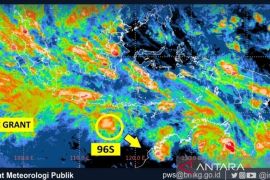
Jakarta (Antara Bali) - Extreme weather is forecast to hit certain marine areas in Indonesia and could trigger waves of up to six meters in height at the end of January, a meteorology official has warned.
"The extreme weather is predicted on January 25-29. During this period, the height of waves could reach up to six meters. This could endanger shipping activities, so stakeholders of the shipping industry should take anticipatory steps," Yunus Subagyo, deputy of the Meteorology, Climatology and Geophysics Agency (BMKG), stated.
Yunus remarked that the height of waves in several areas of Indonesia's maritime territory would reach between 1.25 and 2.5 meters. High waves are likely to occur in the western parts of Indonesia in Sumatra, southern part of Sunda Strait, Natuna Sea, Makassar Strait, Sulawesi Sea, Maluku Sea, Banda Sea, Sumbawa, Flores, and the Arafura seas as well as in the southern part of Java Sea to Bali.
Waves reaching heights of between 2.5 to four meters can be witnessed in the waters of North Aceh, Natuna Islands, Anambas Islands, the southern parts of West and East Nusa Tenggara, the Talaud Island, Halmahera, the northern part of the Pacific Ocean, and Halmahera-Papua waters.
High waves reaching heights of up to four meters are forecast in the South China Sea and the eastern parts of the Philippines.
He said most areas in Indonesia would experience the peak of the rainy season during the January-February 2016 period. Heavy rains can be accompanied by strong winds. Almost 90 percent of Indonesia's areas will be hit by heavy rains and strong winds until the second week of February 2016.
Therefore, he stated that the rains in the current season will affect transportation activities on land, at sea, and in the air.
"All related agencies, such as the Ministry of Transportation, should take anticipatory steps with regard to the various modes of transportation, so that they would not endanger the lives of their users," he emphasized. (WDY)


